
Draper successfully tests alternative GPS navigation technologies, including celestial navigation, vision-assisted navigation, and opportunistic signals.
Draper recently completed more than 30 hours of flight testing for its GPS alternative navigation technologies for military and aerospace applications. The tests evaluated three primary systems:
- Celestial Navigation System (CNS): Uses Skymark technology to determine position based on the stars.
- Vision-Assisted Navigation (VAN): uses visible and infrared images to maintain navigation without GPS.
- Signals of Opportunity (SOOP): exploits radio frequency signals from low-orbit satellites for navigation.
These technologies are designed to provide reliable navigation in environments where GPS is unavailable or degraded.
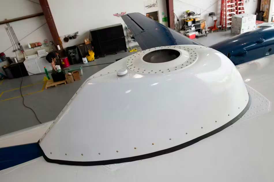
Celestial navigation: 30-meter accuracy without GPS
Draper’s Celestial Navigation System (CNS), based on Skymark technology, has demonstrated navigation accuracy of less than 30 meters in flight tests. The system, which measures 1.5 cubic feet (approximately 42.5 liters), is designed to operate in unpressurized and unconditioned compartments, meeting MIL-STD-810 and MIL-STD-461 environmental standards.
Skymark uses a combination of advanced optics, sensors, and algorithms to triangulate position based on known celestial objects. This technology is already in production for the US Navy’s Arleigh Burke-class destroyers and is being adapted for other platforms, including land and space vehicles.
The use of celestial navigation offers a robust alternative to GPS, particularly in environments where GPS signals may be jammed or unavailable. However, it is dependent on weather conditions and star visibility, which can limit its effectiveness in certain situations.
Vision-assisted navigation: autonomy in degraded environments
Draper’s vision-assisted navigation (VAN) uses visible and infrared images to maintain navigation without relying on GPS. This system has been successfully tested at altitudes ranging from 100 meters to 100 kilometers, including during high-altitude night flights and over water.
VAN is capable of operating in low-light conditions and is particularly useful in environments where GPS signals are unavailable or degraded. It is also being adapted for space applications, including lunar missions, where it can aid navigation by using terrain features as landmarks.
The integration of VAN with other navigation systems, such as inertial measurement units (IMUs), improves the accuracy and reliability of navigation in complex environments.
Opportunity signals: leveraging existing signals for navigation
Draper’s Opportunity Signal System (SOOP) uses existing radio frequency signals, such as those from low-orbiting Internet satellite constellations, for navigation. By collecting these signals using a Ku-band receiver, the system can determine position based on the Doppler effect.
SOOP is designed to be lightweight, compact, and energy efficient, making it suitable for a variety of platforms, including unmanned aerial vehicles and satellites. It offers an alternative navigation solution in environments where GPS is unavailable or jammed.
However, the effectiveness of SOOP depends on the availability and density of radio frequency signals in the environment, which can vary depending on geographic location and operational conditions.
Implications for military and aerospace operations
The development of these alternative navigation technologies has significant implications for military and aerospace operations. By providing reliable navigation solutions in environments where GPS is unavailable or degraded, they enable operational capability to be maintained in contested situations.
These systems can be integrated into a variety of platforms, including aircraft, ground vehicles, ships, and satellites, providing increased operational flexibility. They also contribute to the resilience of navigation systems by providing alternatives in the event of GPS failure or jamming.
The adoption of these technologies could also influence operational doctrines and engagement strategies, enabling operations in environments previously considered inaccessible due to GPS dependence.
Future prospects and developments
Draper continues to develop and improve its alternative navigation technologies, with plans to integrate these systems into operational platforms by the end of 2026. The company is also exploring other navigation modalities, such as magnetic navigation and high-precision clocks, to complement its existing solutions.
The maturation of these technologies and their integration into operational systems could transform how military forces and space agencies approach navigation in contested environments. They offer the potential to reduce dependence on GPS and improve the resilience and flexibility of operations.
War Wings Daily is an independant magazine.