
Orbital Sidekick hyperspectral sensors reveal major underground damage after bombing of Iran’s Fordow nuclear site.
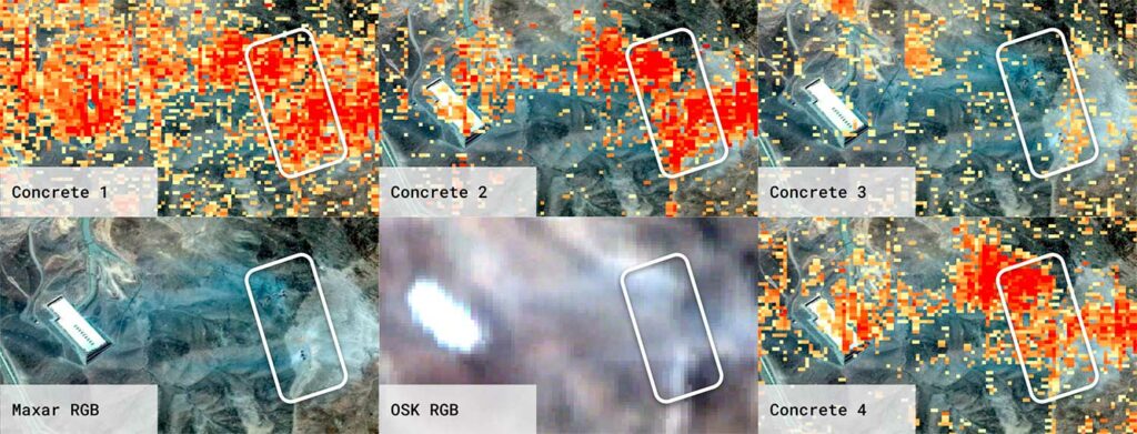
Orbital Sidekick used its GHOSt constellation of hyperspectral images to detect, from a distance of ~500 km, damaged structures beneath Fordow, Iran’s nuclear enrichment plant, following a US air raid in June. Three types of concrete were identified around impact holes, and a rectangular underground structure appears to have collapsed or been severely altered. These observations go beyond what conventional electro-optical imaging could see. These technologies pave the way for widespread applications in damage monitoring and chemical or environmental leak detection.
Analysis of the effects of the bombing of Fordow in Iran
Orbital Sidekick (OSK), through its Global Hyperspectral Observation Satellite (GHOSt) constellation, analyzed the effects of a US bombing raid on the Fordow nuclear enrichment facility in Iran in June.
Using hyperspectral images—which capture the intensity of light in a wide range of spectral bands—OSK identified:
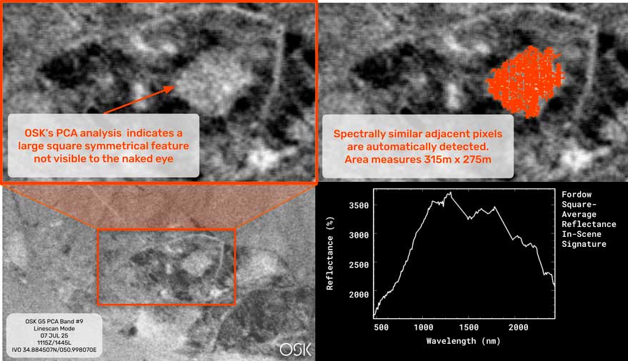
- the presence of a rectangular underground structure whose shadow or contours are visible, suggesting a partial collapse or cave-in.
- Three types of concrete around the areas where the bombs are believed to have penetrated.
- A fourth site where no concrete was detected, which could mean that the impact or destruction removed or dislocated the concrete layer.
These results complement and refine the observations obtained by electro-optical imaging—normally limited to visible surfaces, color changes, or external shape, whereas hyperspectral imaging allows specific materials (type of concrete, spectral signatures) to be recognized even under certain coverings.
The technical and strategic context of hyperspectral imaging
Hyperspectral imaging involves measuring the reflectance of light in hundreds of narrow spectral bands. This makes it possible to distinguish materials according to their “spectral fingerprint”: concrete, soil, water, chemicals, etc. This technique is already used in precision agriculture (plant health analysis), mineral processing (mineral identification), and land management. OSK aims to extend its use to damage assessment and chemical leak detection.
Strategically, for sensitive sites such as Fordow—often underground, heavily camouflaged, or subject to access restrictions—hyperspectral space imaging offers an advantage: remote observation capability that is non-invasive and does not require entering airspace or conflict zones. OSK points out that aircraft or drones may not be able to legally or physically access the site, making satellites the only viable source of critical information.
Figures and concrete examples
- Capture distance: GHOSt satellites operate from an altitude of ~500 kilometers. This allows them to cover vast regions while maintaining sufficient resolution to identify precise spectral signatures.
- Types of concrete: Three distinct types have been identified around suspected impact holes. The variation may be due to different qualities or formulations of concrete (different aggregates, binders, densities). This can help diagnose the nature of the structure, its robustness, or the type of impact it has undergone.
- Underground structures: The presence of a rectangular underground construction indicates a regular, unnatural geometry that was not visible through traditional imaging. Collapse or damage may mean structural loss, slab subsidence, and possible compromise of certain internal installations (tunnels, pipes, equipment).
Concrete example: after an earthquake, hyperspectral imaging can be used to detect hydrocarbon leaks when underground reservoirs crack—oil or fuel alters the reflectivity of soil or water tables. OSK also mentions relief efforts after natural disasters, derailed trains with fertilizer spills, and leaks from pipelines.
Consequences of these discoveries
On a military and geopolitical level
- Hyperspectral observations enhance international transparency: they enable states, civil organizations, and the media to document damage that the site owner might otherwise conceal.
- They can fuel investigations into compliance with international treaties (nuclear non-proliferation): damage to enrichment facilities, leaks, or the release of hazardous materials or effluents may have legal implications.
- They change strategic posture: knowing that a site is vulnerable can be a deterrent, but it can also encourage the strengthening of protections or changes in underground construction techniques.
Scientific and technological
- Improved damage monitoring and diagnostic capabilities: accurate identification of damaged materials, concrete types, etc., enables a more detailed post-incident assessment.
- Development of new spectral recognition algorithms: signature catalogs, machine learning, calibration according to local geology and climate, etc.
- Integration with other types of data: radar imaging (SAR), lidar, electro-optics, in situ data (if accessible) to confirm observations.
Environmental and population risks
- Risks associated with the destruction or cracking of underground storage structures: chemicals, isotopes, and radionuclides could be released into the soil or groundwater.
- Risks of atmospheric or water contamination: even though the article does not mention the detection of specific chemicals, the rupture of storage structures could pose this type of problem.
- Need for intervention or remediation: some areas may require cleanup, increased monitoring, or containment measures.
Challenges for the market and monitoring policy
- The hyperspectral satellite market is growing. Many companies (OSK, but also other private and public players) are investing in onboard hyperspectral sensors. This market is estimated to grow by several tens of percent per year, driven by security, environmental, and risk management needs.
- In the defense and intelligence sector, demand for high spectral resolution imaging services is increasing, especially for inaccessible or militarized areas.
- Politically, the use of this type of data can put pressure on states: publicity of damage, expectations of transparency, international obligations. Some states may restrict access or attempt to challenge the observations or their interpretation.
Limitations and issues to consider
- Spatial resolution: although hyperspectral imaging can identify material signatures, its geometric resolution may be less accurate than that of certain electro-optical sensors. If the damage is very localized or the materials are very small, they may escape detection.
- Atmospheric and geological effects: Vegetation, soil, weather, dust, shadows, and topography can alter or mask spectral signatures. Complex correction models and local calibrations are required.
- Field validation: Without in situ confirmation, there may be uncertainties about what is detected. For example, identifying a type of concrete from spectral signatures requires known references or samples.
- Interpretation issues: The presence or absence of concrete is not necessarily proof of the presence or absence of damage; sometimes concrete may have been covered, moved, or damaged in a way that alters its spectral signature without making it invisible.
War Wings Daily is an independant magazine.